


Similkameen Voting District, Okanogan County, Washington
About
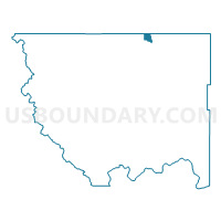
Outline

Summary
| Unique Area Identifier | 687637 |
| Name | Similkameen Voting District |
| County | Okanogan County |
| State | Washington |
| Area (square miles) | 9.82 |
| Land Area (square miles) | 9.69 |
| Water Area (square miles) | 0.13 |
| % of Land Area | 98.70 |
| % of Water Area | 1.30 |
| Latitude of the Internal Point | 48.97761490 |
| Longtitude of the Internal Point | -119.48101320 |
Maps


Graphs
Select a template below for downloading or customizing gragh for Similkameen Voting District, Okanogan County, Washington


Neighbors
Neighoring Voting District (by Name) Neighboring Voting District on the Map
- Blue Lake Voting District, Okanogan County, WA
- Boundary Voting District, Okanogan County, WA
- Nighthawk Voting District, Okanogan County, WA
- Oroville 10 Voting District, Okanogan County, WA
- Oroville 5 Voting District, Okanogan County, WA
- Oroville 7 Voting District, Okanogan County, WA
- Oroville 8 Voting District, Okanogan County, WA
- Oroville 9 Voting District, Okanogan County, WA
- Shoreline Voting District, Okanogan County, WA
- Westlake Voting District, Okanogan County, WA